Key points
- NASA's sea-level satellites show the Pacific in October 2026 looking like October 1997, the year of the last great El Niño.
- NOAA's October 8 outlook gave an 83% chance of a strong to very strong event from January to March 2027.
- NASA's Josh Willis says similar looks do not guarantee similar effects, and the impacts remain uncertain.
NASA’s sea-level satellites show the Pacific Ocean in a state that closely resembles October 1997, the year of one of the strongest El Niños on record, and a NASA scientist says this year’s event is “on track to be even bigger”.
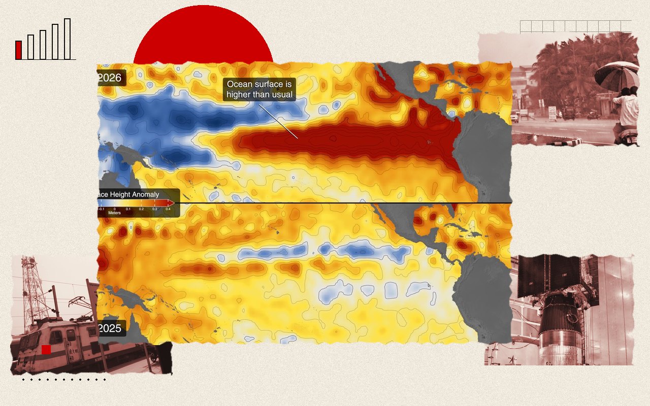
The comparison comes from NASA’s Earth Observatory, which published side-by-side sea-surface height maps on October 23, 2026, and was widely repeated on November 15. It sets October 12, 2026, as measured by the Sentinel-6 Michael Freilich satellite, against October 13, 1997, from TOPEX/Poseidon, and October 12, 2015, from Jason-2.
What the maps show
In October 2026, sea levels were higher than normal across the central and eastern equatorial Pacific. Warm water, which stands taller than cool water, stretched east along the equator all the way to South America. That is the same shape seen in 1997.
The 2015 event, also a very strong one, looked different. Its elevated water stayed farther offshore and did not push against the South American coast to the same extent. NASA notes that the winter rainfall that year was concentrated over Central America and the south-eastern United States, with significant flooding in Mexico.
To bring out the El Niño signal, the maps remove seasonal cycles and long-term trends. The analysis draws on about 35 years of satellite altimetry.
“Even bigger”
Josh Willis, a NASA Jet Propulsion Laboratory project scientist for the sea-level missions, said the 2026 event arrived much more suddenly than the 1997 one. As of October, he said, “this one is on track to be even bigger”. He also warned against reading too much into the likeness: “Just because this El Niño looks like 1997 doesn’t mean it will be exactly the same.”
“There’s always a bit of a dice roll here,” Willis said. He added that the search for a “typical” El Niño is “very elusive”, and that the signal can get muddled as it travels beyond the tropics, so exact effects for the winter of 2026-27 remain uncertain.
The forecast
The US National Oceanic and Atmospheric Administration’s (NOAA) outlook of October 8, 2026, gave an 83% chance of a strong to very strong El Niño from January to March 2027, according to NASA. El Niño typically recurs every two to seven years.
Three Octobers compared
How we got here
NASA’s account says earlier very strong events, in 1997-98 and 2015-16, affected weather around the world, from fires in Indonesia and the Amazon to drought in southern Africa. In 1997-98 the effects included heavy rain in California and the southern United States.
What it means for India
NASA’s article does not forecast Indian weather, but El Niño has long been tied to a weaker monsoon, and the warming Pacific has already been part of the story here. India’s 2026 monsoon finished about 13% below normal, its weakest season in a decade, and East and Northeast India recorded their driest monsoon since 1901. The India Meteorological Department has said it expects below-normal rain across most of the country from October to December.
States have started preparing. Telangana’s chief secretary ordered a drinking water plan for Hyderabad in October after the state warned of a severe El Niño, and the UN climate talks at COP31 in Antalya are under way.
What to watch
The next marker is NOAA’s monthly update on El Niño, which sets out whether the event has reached strong status and how long it is expected to last. For readers, the practical question is the same one the maps raise: whether a Pacific that looks like 1997 produces the same winter and the same summer. NASA’s scientists are clear that the likeness is a reason to prepare, and not yet a forecast of the outcome.
The documents
- El Niño Then and NowNASA Earth Observatory, October 23, 2026